The heaviest precipitation arrived early Wednesday, producing rainfall rates at or above one inch per hour from Santa Monica to San Bernardino. In Wrightwood, a mountain community in San Bernardino County, mandatory evacuations were ordered after water and debris made State Route 2 impassable. Elsewhere, crews rescued stranded motorists from roadways that quickly turned into streams. The California Highway Patrol reported one death in an apparent weather-related crash in Sacramento County.
Transportation officials advised drivers to avoid major arteries likely to flood, including Interstate 10 between San Bernardino and Santa Monica, U.S. 101 toward Thousand Oaks, and the Interstate 5 and Interstate 210 corridors through Burbank, Santa Clarita and up to Pyramid Lake. Low-lying neighborhoods near these routes face an elevated risk of street flooding through the holiday travel period.
Meteorologists attributed the prolonged onslaught to successive atmospheric rivers—narrow bands of moisture originating over the Pacific Ocean. As each plume slams into the California coast, it forces warm, moisture-laden air upward, squeezing out torrents of rain and generating strong onshore winds. Gusts of 40 to 50 miles per hour were common Wednesday and knocked out electricity to more than 100,000 customers statewide.
Thunderstorms added to the instability, producing frequent cloud-to-ground lightning and isolated hail. While damaging winds posed the main severe-weather threat, forecasters did not rule out the possibility of brief tornadoes anywhere along the coast. Residents were urged to monitor local warnings and have multiple ways to receive alerts if rotating storms developed.
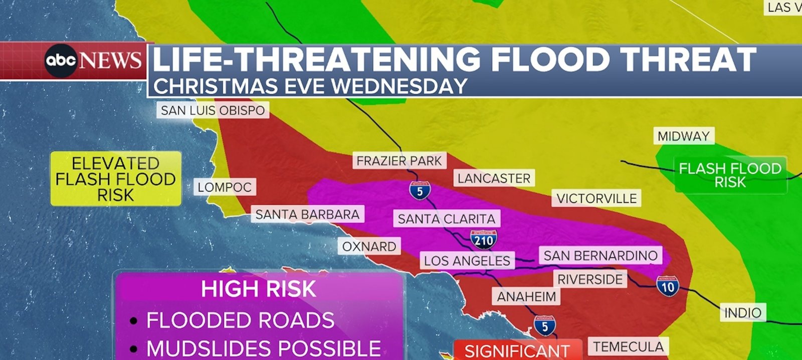
Imagem: Internet
The initial band of rain was expected to taper by early evening, offering only a temporary reprieve. Forecast models show additional waves arriving overnight and persisting through Thursday and Friday. With soils already saturated, even moderate showers could renew flooding, particularly near creeks, streams and rivers that have risen quickly since Tuesday.
Emergency managers said the combination of saturated ground, steep terrain and burn scars dramatically increases the likelihood of rockslides and mudslides. Rapid debris flows can overtake roads or properties in minutes, making evacuation orders time-sensitive. Urban centers such as Los Angeles, San Diego and Sacramento could also see widespread roadway flooding that hampers first responders and holiday travelers.
Authorities advised residents to keep cell phones charged in case of power failures, avoid driving through water of unknown depth, and prepare for potential evacuation if they live below hillsides or within past fire perimeters. Travelers were urged to reconsider or delay trips until the weather pattern breaks later in the week.
Although Southern California bears the brunt of the current system, forecasters noted that Central and Northern California remain at risk for additional heavy rain and mountain snow through the weekend. Emergency crews will continue to pre-position swift-water rescue teams, high-clearance vehicles and shelter resources as the state watches for further impacts from this persistent series of winter storms.
Crédito da imagem: San Bernardino County Fire/X


