Minor icy spots developed on untreated roads and walkways, and travelers were urged to proceed cautiously during the morning hours. By mid-morning, precipitation had tapered off and surfaces began to dry as ground temperatures in many locations crept above freezing.
Stronger Arctic Outbreak Arrives Early Next Week
Another, more potent mass of cold air is forecast to descend from Canada on Sunday night into Monday, driving daytime highs in the Midwest and interior Northeast back toward the freezing mark and pushing overnight lows to near or below zero in several communities. The impending outbreak follows a pattern of sharp temperature swings that has characterized early December across large sections of the country.
While the central and eastern states cool down, the West is projected to trend warmer. Some valleys in California and the Desert Southwest could challenge daily record highs during the first half of next week, illustrating the pronounced temperature contrast from coast to coast.
Snowstorm Tracks Across the Northern Plains and Upper Midwest
Before the deeper chill settles in, a quick-moving winter storm will slide southeastward across the northern Plains on Saturday, spreading into the Upper Midwest by Sunday. Snow will begin in the Dakotas and Nebraska during the morning, reach Iowa and Minnesota in the early afternoon, and advance toward Wisconsin and northern Illinois Sunday evening.
The heaviest snowfall is expected in central and northern Iowa and southern Minnesota, where totals of 3 to 7 inches are possible by sunrise Sunday. A Winter Storm Warning has been issued for Fort Dodge, Waterloo, Mason City, and Worthington in response to the anticipated impacts.
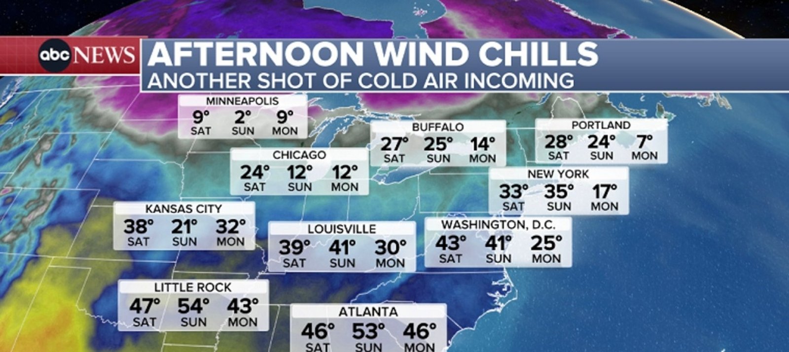
Imagem: Internet
Farther east, Chicago and Milwaukee may see the first flakes by Sunday evening. Accumulations in those metropolitan areas are forecast to range from 3 to 4 inches, with slightly higher amounts likely west of the city centers. Light snow of 1 to 3 inches should extend from portions of Montana and the Dakotas southward into southern Wisconsin and northern Illinois.
As the system continues toward the Great Lakes, it will weaken, limiting snowfall in the Northeast to intermittent lake-effect bands downwind of Lakes Erie and Ontario. Nonetheless, the storm’s passage will help usher the next influx of frigid air across the region.
Significant Mountain Snow in the Rockies
Separate from the Plains system, a prolonged upslope flow is generating heavy snowfall in the higher terrain of the northern and central Rockies. Elevated areas from Idaho and Montana south to Colorado and Utah remain under Winter Weather Advisories or Winter Storm Warnings, with many locations expected to collect more than one foot of snow and isolated corridors topping two feet.
The mountain snowfall is forecast to persist through Saturday night before gradually diminishing on Sunday. The storm will enhance early-season snowpack and may benefit ski resorts across the region, though it also poses travel hazards on mountain passes.
Preparing for Rapid Weather Shifts
Residents in affected areas are encouraged to monitor the latest statements from the National Weather Service and local authorities, as rapid changes in temperature and precipitation can create challenging travel and outdoor conditions. The brief respite in wind chills on Saturday will be followed quickly by a harsher Arctic intrusion, reinforcing the need for layered clothing, vehicle winterization, and flexible travel plans.
Crédito da imagem: Daniel Heuer/Reuters


