On the opposite side of the country, a developing Pacific system is expected to reach the West Coast Tuesday night. Travelers on Interstate 5 and U.S. Highway 101 are advised to complete trips during daylight hours, as the approaching storm is likely to deliver heavy rain, strong onshore winds and rapidly deteriorating driving conditions after sunset.
Wednesday (Christmas Eve): Southern California Faces Flood Risk
Much of the continental United States should experience relatively quiet weather on Christmas Eve. The notable exception is Southern California, where the same Pacific storm will intensify. Meteorologists have assigned a level 3 of 4 risk for excessive rainfall over recent wildfire burn scars, raising concerns about flash flooding, debris flows and landslides.
Rainfall totals could reach 9 inches in localized areas between Tuesday night and late Wednesday. Communities near hillsides previously stripped of vegetation by fires are particularly vulnerable, as soils may not absorb the incoming moisture. Residents and visitors are urged to follow any evacuation advisories and monitor updates from the National Weather Service.
Away from the West Coast, most regions will have calm weather, aiding last-minute shopping and travel by road or air. Temperatures will remain near seasonal averages in the Great Lakes, the Mid-Atlantic and the Southeast.
Thursday (Christmas Day): Widespread Warmth and Ongoing Western Storms
Christmas Day may bring record or near-record warmth from the southern Plains through the lower Mississippi Valley and into parts of the Mid-South and Southeast.
- Albuquerque, New Mexico: 66 °F (potential record)
- Rapid City, South Dakota: 66 °F (potential record)
- Midland, Texas: 79 °F (potential record)
- St. Louis, Missouri: 77 °F (potential record)
- Atlanta, Georgia: 75 °F (potential record)
- Austin and Houston, Texas: near 80 °F
- Miami and Orlando, Florida: 79 °F
- Memphis, Tennessee: 72 °F
- Washington, D.C.: 53 °F
The dramatic warmth reduces the likelihood of a widespread white Christmas. However, inland areas of New England have a reasonable chance of retaining Tuesday’s snow cover through Thursday. Additionally, higher elevations in Washington, Oregon, Idaho, Montana, Colorado and Northern California should maintain or receive fresh snow, ensuring holiday scenes common to mountain resorts.
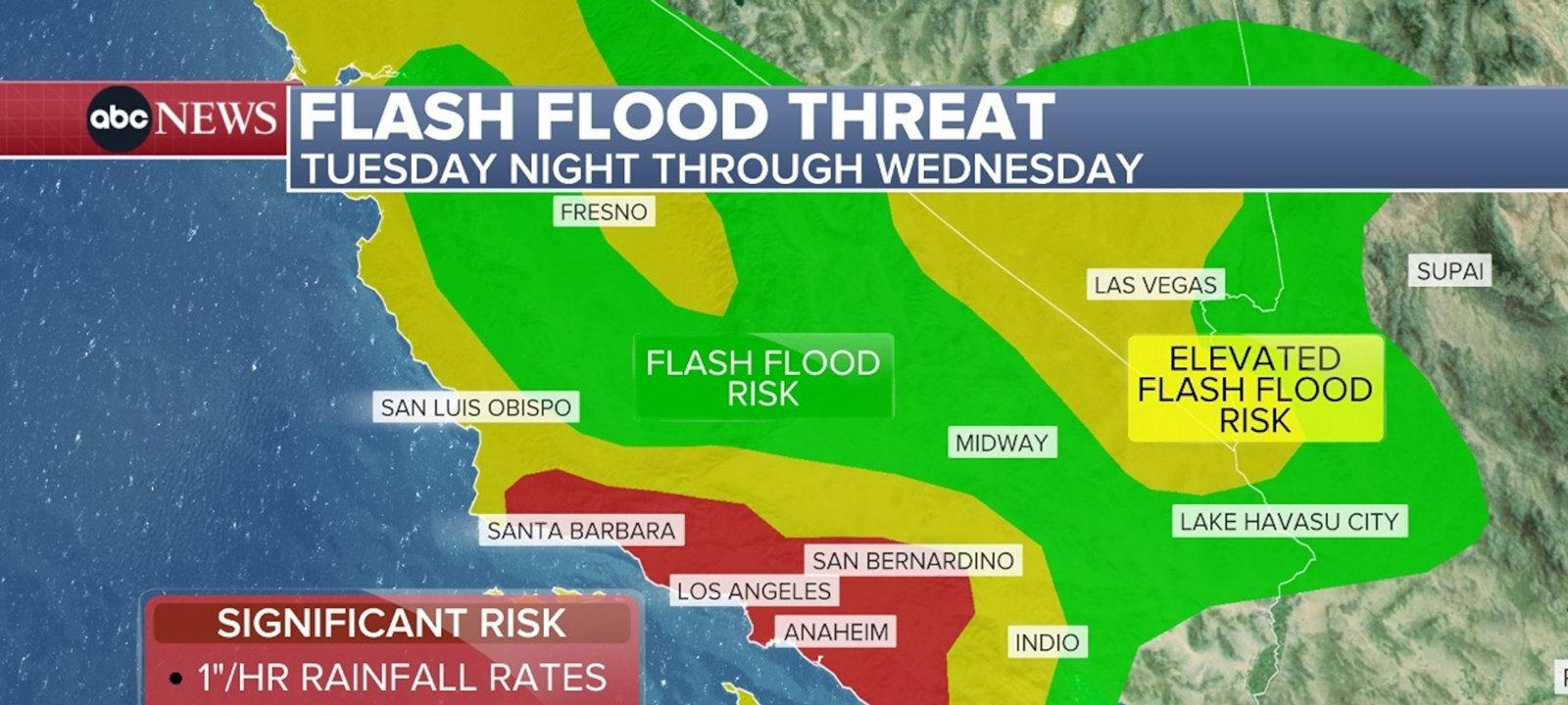
Imagem: Internet
Meanwhile, the Pacific storm will send a second wave of moisture into California and the Pacific Northwest on Christmas Day. Coastal communities can expect more rain, while mountain ranges such as the Sierra Nevada and the Cascades are forecast to pick up additional snow, complicating travel through passes and over summits.
Travel Implications
The Transportation Security Administration anticipates the busiest holiday travel period on record. Snow-related slowdowns in the Northeast on Tuesday morning could create cascading delays for flight routes nationwide. Equally, heavy rain and wind along the West Coast may prompt airline schedule adjustments and hazardous roadway conditions, especially on canyon roads and near burn scar zones in Southern California.
Travelers are advised to check airline notifications, allow extra time for security screening, and carry flexibility in itineraries. Motorists crossing mountainous terrain in the West should pack emergency supplies and verify that chains or snow-rated tires meet local requirements.
Although much of the central and eastern United States will avoid significant precipitation, the forecast warm spell may place additional demand on energy systems as households adjust heating and cooling needs.
Overall, weather impacts will be highly regionalized: light snow in the Northeast early in the week, intensifying rain and flood concerns in California, and unusual warmth across large portions of the country on Christmas Day. Staying informed through official forecasts and local advisories will remain critical for anyone traveling during this record holiday season.
Crédito da imagem: ABC News


