Infrastructure damage and power outages expected
Government officials have cautioned that Melissa’s wind field and prolonged rainfall are likely to cause extensive damage to infrastructure, including roads, bridges, and utility networks. Prolonged power outages are anticipated, and emergency services have urged residents to prepare for limited access to electricity, potable water, and communications for an extended period.
Outer rainbands will reach Haiti on Tuesday, bringing tropical-storm-force winds and periods of heavy rain. Although Haiti is not forecast to receive a direct hit, saturated soils and steep terrain make the country vulnerable to flash flooding and landslides.
Track beyond Jamaica
By Tuesday night, forecast models show Melissa pulling away from Jamaica and moving toward eastern Cuba. Meteorologists expect 15 to 20 inches of rain across Cuba’s eastern provinces, conditions that could result in dangerous flash flooding and hillside collapses.
On Wednesday afternoon, the system is projected to approach the southeast Bahamas, where 4 to 8 inches of rain and tropical-storm-force winds are possible. Some strengthening or fluctuations in intensity are likely as the hurricane moves over warm Atlantic waters.
Current guidance suggests Melissa could bring hurricane conditions to Bermuda by Thursday. Output from several global models remains consistent, but forecasters caution that any deviation in the storm’s track or speed could alter impacts in the Bahamas and Bermuda.
Preparedness efforts underway
Jamaican authorities have activated national disaster response plans. Shelters across the island are open, and the military has been deployed to assist with evacuations. Hospitals and clinics have stocked medical supplies to handle storm-related injuries, while utility crews stand ready to begin post-storm repairs.
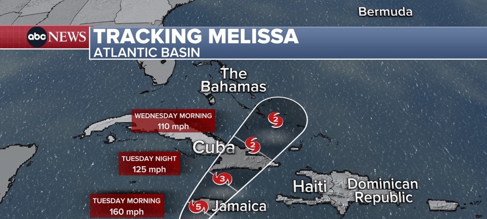
Imagem: Internet
Regional partners are also on alert. Cuban civil defense units have issued advisories to residents in mountainous areas, and the Bahamian government has urged communities in low-lying islands to monitor updates closely.
Forecast and monitoring resources
Residents throughout the Caribbean are encouraged to follow official advisories and heed local emergency directives. Detailed, real-time updates are available from the National Hurricane Center, which continues to monitor Melissa’s intensity and trajectory.
As of Monday afternoon, the hurricane is moving slowly northwest, a behavior that prolongs exposure to dangerous conditions wherever the core passes. Coastal and inland flooding, combined with destructive sustained winds and higher gusts, remain the primary threats through midweek.
Transportation disruptions are expected across the region. Several airlines have canceled flights to and from Jamaica, and shipping operations at Kingston Harbor have been suspended. Authorities have advised motorists to avoid non-essential travel once conditions begin to deteriorate.
Meteorologists note that Melissa’s rapid intensification reflects favorable atmospheric and oceanic conditions in the western Caribbean. Sea-surface temperatures well above average and low wind shear have enabled the storm to achieve Category 5 status shortly before its approach to Jamaica.
Next advisories
The National Hurricane Center will issue its next complete advisory at 5 p.m. local time. Emergency managers stress that all precautions should be rushed to completion, as deteriorating weather could make last-minute preparations dangerous or impossible.
Crédito da imagem: ABC News


