Accumulations over the 18-hour period are expected to range from 3 to 7 inches broadly, with isolated pockets potentially reaching 9 inches or more. For perspective, December normally delivers 2 to 3 inches of rain to the region.
Burn Scar Vulnerability
Recent wildfires, including January’s Palisades and Eaton fires, have stripped vegetation and altered soil structure in parts of Los Angeles and Ventura counties. Burned soil can repel water nearly as effectively as pavement, causing rainfall that would typically infiltrate the ground to run off rapidly. Hydrologists note that as little as half an inch of rain in under an hour can trigger flash flooding on a fresh burn scar, with risk peaking during the first two years after a fire.
Evacuation warnings are in place from Tuesday through 11 p.m. Thursday for the Palisades, Sunset and Hurst burn areas. Targeted evacuation orders cover several high-risk properties; Los Angeles Police Department officers have been conducting door-to-door notifications.
Projected Impacts
Forecasters anticipate significant and widespread urban flooding, rapid rises in creeks and rivers, and an elevated likelihood of mudslides and rockslides, particularly near steep terrain. Freeways, canyons and low-lying neighborhoods could see fast-developing high water, prompting possible swift-water rescues and prolonged travel disruptions.
Ariel Cohen, meteorologist-in-charge at the NWS Oxnard office, said the combination of prolonged rainfall and vulnerable terrain makes driving “exceptionally dangerous,” with numerous slide-prone roadways expected to close.
Wind Threat Compounds Hazards
Beginning Tuesday night, strong southerly winds are forecast statewide. High-wind warnings call for gusts of 60–70 mph in mountain and foothill zones, including Sacramento, Redding, Santa Barbara and Santa Clarita. Isolated mountain peaks could experience gusts exceeding 70 mph. Along the coast, wind advisories cover Los Angeles, San Francisco and San Diego, where gusts of 40–50 mph may topple trees and down power lines.
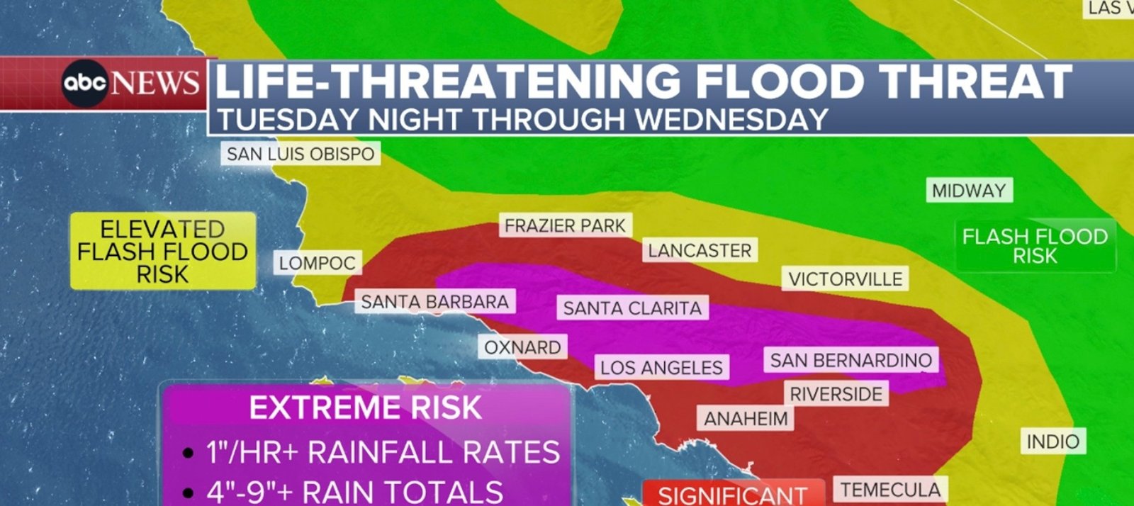
Imagem: Internet
Hydroclimate Whiplash Context
California’s recent swing from severe drought to above-average precipitation has fostered dense vegetation growth. When followed by extreme heat and winds, this surplus fuel contributes to larger wildfires, which in turn leave slopes prone to debris flows once heavy rains return. Scientists describe the cycle as “hydroclimate whiplash,” a rapid shift between wet and dry extremes that amplifies both fire and flood hazards.
Communities downstream of burn scars are urged to monitor official updates, heed evacuation instructions and avoid flood-prone roadways. Residents should also prepare for potential power outages and flight cancellations as the storm coincides with peak holiday travel.
The NWS advises that conditions may evolve quickly; even moderate rainfall could overwhelm drainage systems where soils remain hydrophobic after fire. Emergency managers recommend having go-bags ready, securing outdoor objects and relocating vehicles away from canyon mouths and low-lying streets.
While the greatest flash-flood risk centers on Southern California, the northern half of the state will chiefly contend with damaging winds. Utility crews are on standby for widespread outages, and transportation officials caution that blowing debris may close mountain passes.
The atmospheric river is expected to shift east by Thursday night, but additional Pacific systems remain possible later in the holiday period. Until the moisture plume dissipates, officials emphasize that residents in and around recent burn scars should remain vigilant and treat all flood warnings as urgent.
Crédito da imagem: David McNew/Getty Images


