Travel disruptions already under way
Airlines had canceled more than 1,400 flights scheduled for Saturday, according to early tracking data, as carriers anticipated icy runways and poor visibility. Airports serving Dallas–Fort Worth, Atlanta and Charlotte are expected to experience the most significant operational challenges. Road travel is also likely to deteriorate quickly once precipitation begins; transportation departments in several states have started pretreating highways with salt brine to slow the formation of ice.
Brutal cold compounds the danger
While the storm delivers snow and ice, a separate surge of Arctic air is driving temperatures well below normal across much of the central United States. More than 50 million people from Minneapolis to Houston are under alerts for extreme cold. Wind-chill readings dipped near −40 °F in Minneapolis and −30 °F in Chicago early Friday, conditions that can produce frostbite on exposed skin in as little as 10 minutes.
Southern cities unaccustomed to prolonged freezes—among them Dallas, Little Rock and Memphis—are forecast to remain below freezing for an extended period even after the main storm axis moves east. Because widespread power outages are likely where ice accumulates, local officials fear many residents could be left without heat during the coldest spell of the season.
Storm timeline and geographic reach
The expansive weather system began organizing over the Southwest on Friday afternoon, depositing snow and sleet in New Mexico. Forecasters anticipate the following progression:
- Friday evening: A wintry mix develops over the Dallas–Fort Worth area, while snow spreads into Oklahoma City.
- Saturday morning: Freezing rain stretches from San Antonio to Dallas and eastward through Little Rock, Memphis and Shreveport, Louisiana, reaching Tupelo, Mississippi.
- Saturday evening: Snow and ice extend from New Mexico through the Carolinas. Raleigh and Atlanta are likely to see a mix of sleet and freezing rain.
- Early Sunday: Snow reaches from Wichita, Kansas, to Cincinnati and Washington, D.C., while freezing rain threatens Houston, Memphis, Atlanta and Raleigh.
- Midday Sunday: New York City transitions from dry conditions to snow; Washington, D.C., may change from snow to a wintry mix as temperatures rise slightly.
- Late Sunday: Snow is expected along a corridor from Louisville through Chicago to New York City, while coastal sections of the Northeast oscillate between rain and snow.
- Early Monday: Interior portions of the Northeast and much of New England remain under accumulating snow as the system departs.
Potential snow totals
Accumulations will vary widely along the storm track. Cities such as Albuquerque, New Mexico; St. Louis; and Virginia Beach, Virginia, could observe measurable snow for the first time this winter. Interior New England may collect the deepest totals, though precise amounts hinge on how quickly coastal temperatures rise above freezing.
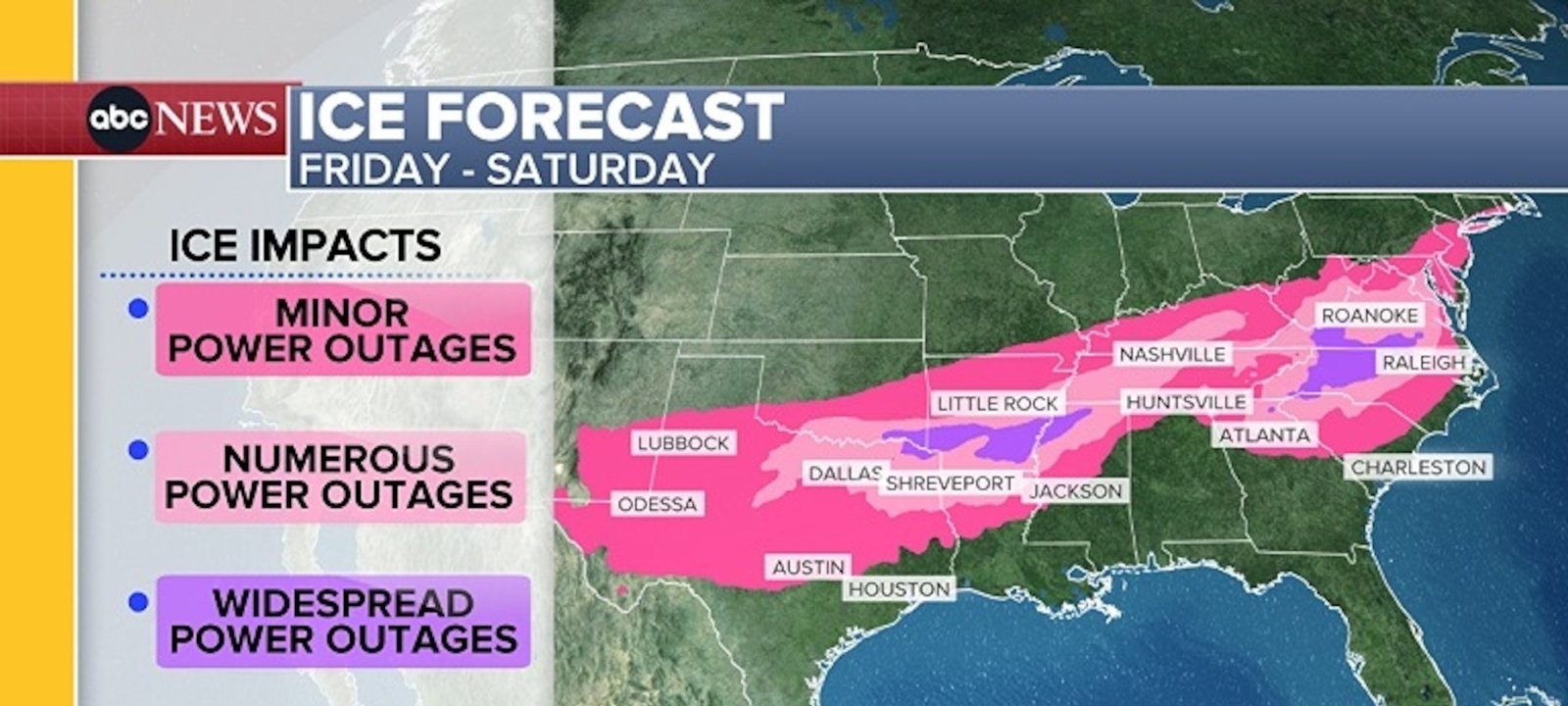
Imagem: Internet
Power grid and infrastructure concerns
Utility companies across the South and Mid-Atlantic have placed line crews on standby, anticipating ice-induced outages. Up to 1 inch of ice loading is historically associated with extensive damage to distribution networks. Some providers have urged customers to prepare for multiday interruptions and to stock emergency kits in advance.
Transportation agencies emphasize that even modest ice accumulations can shut down interstates. Motorists are advised to avoid travel during the height of the event, especially in regions where ice rather than snow is expected to dominate.
Federal coordination and public guidance
The National Weather Service continues to issue updated watches and warnings as new data arrive. Federal Emergency Management Agency officials report ongoing coordination with state authorities to ensure generators, blankets and other resources are positioned where the need is projected to be greatest.
Meteorologists stress that the combination of slick roads, potential power failures and dangerous cold could create life-threatening conditions, particularly for vulnerable populations. Residents in the storm’s path are urged to monitor local alerts, limit travel, insulate exposed pipes and verify that alternative heat sources are safe and operational.
Next steps
The storm’s strength and broad reach make it one of the most consequential winter weather events of the season. Tracking will continue through the weekend as forecasters refine snowfall projections and ice probabilities. Authorities caution that even minor shifts in temperature profiles could significantly alter the balance between snow, sleet and freezing rain, thereby changing impact zones.
Crédito da imagem: George Walker IV/AP


