Expected Snow Totals
The highest accumulations are likely in New York City, northern New Jersey, the southern Hudson Valley and western Pennsylvania. More than six inches of snow is possible in these areas, and some communities could see totals approaching eight or nine inches before precipitation ends.
Moderate to heavy snow should taper by approximately 4 a.m. Sunday. Light snow showers could linger until between 8 a.m. and 11 a.m. Saturday, when the system is expected to exit the region completely.
Ice Accumulation Concerns
Freezing rain poses a separate threat, particularly in central Pennsylvania. Locations such as Johnstown and Clarion could receive more than one quarter of an inch of ice. The build-up increases the potential for downed tree limbs and scattered power outages, especially if wind gusts accompany the storm.
Elsewhere, up to 0.2 inches of ice is possible across northeastern West Virginia, much of central and northwestern Pennsylvania and portions of Michigan, including Detroit. Washington, D.C., and Baltimore may also experience light icing from Friday into Friday night.
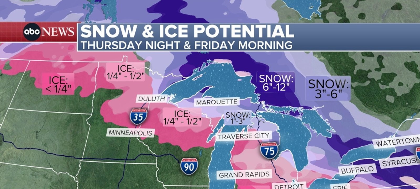
Imagem: Internet
In the upper Midwest, similar ice amounts are anticipated from northern Minnesota through northern Wisconsin and into Michigan’s Upper Peninsula. Roads untreated with salt or sand are expected to turn slick quickly after the onset of freezing rain.
Travel Impact
With many families returning from holiday gatherings, transportation corridors are likely to see disruptions. Motorists on Interstate 80 and Interstate 70 through Pennsylvania are advised to use extreme caution, as ice can form even on well-traveled lanes. Flight delays are also possible at major hubs in Minneapolis, Detroit, New York and Philadelphia as precipitation types shift through the day on Friday.
Advisories and Safety Measures
Weather advisories and watches will be issued by local offices of the National Weather Service as the system approaches. Travelers are urged to monitor updates, allow extra time for commutes, and carry emergency supplies such as blankets, flashlights and non-perishable food in case vehicles become stranded. Residents in ice-prone zones should charge electronic devices and prepare for the possibility of power interruptions.
Outlook Beyond the Weekend
Once the storm departs, forecasts call for calmer weather across much of the affected region. Temperatures are expected to remain seasonably cold, limiting rapid snowmelt but reducing the likelihood of additional storms through the remainder of the weekend.
Crédito da imagem: ABC News / AP


